


Ward Fire Station, Sumter County, Alabama
About
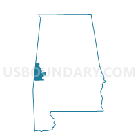
Outline

Summary
| Unique Area Identifier | 522934 |
| Name | Ward Fire Station |
| County | Sumter County |
| State | Alabama |
| Area (square miles) | 86.98 |
| Land Area (square miles) | 86.90 |
| Water Area (square miles) | 0.08 |
| % of Land Area | 99.91 |
| % of Water Area | 0.09 |
| Latitude of the Internal Point | 32.34527660 |
| Longtitude of the Internal Point | -88.25913100 |
Maps


Graphs
Select a template below for downloading or customizing gragh for Ward Fire Station, Sumter County, Alabama


Neighbors
Neighoring Voting District (by Name) Neighboring Voting District on the Map
- Alamucha Voting District, Lauderdale County, MS
- Bellamy Community Center, Sumter County, AL
- Crossroads-Intersection-Halsell Voting District, Choctaw County, AL
- Cuba City Hall, Sumter County, AL
- Pennington-Pelham, Choctaw County, AL
- Whitfield Community Center, Sumter County, AL
- Whynot Voting District, Lauderdale County, MS
- Yantley-Cromwell, Choctaw County, AL
- York Hightower Center, Sumter County, AL
Top 10 Neighboring County Subdivision (by Population) Neighboring County Subdivision on the Map
- District 5, Lauderdale County, MS (16,062)
- York CCD, Sumter County, AL (4,447)
- Lisman CCD, Choctaw County, AL (3,184)
- Cuba CCD, Sumter County, AL (1,215)
Top 10 Neighboring Unified School District (by Population) Neighboring Unified School District on the Map
- Lauderdale County School District, MS (39,113)
- Choctaw County School District, AL (13,859)
- Sumter County School District, AL (13,763)
Top 10 Neighboring State Legislative District Lower Chamber (by Population) Neighboring State Legislative District Lower Chamber on the Map
- State House District 71, AL (38,094)
- State House District 68, AL (36,234)
- State House District 81, MS (22,670)
Top 10 Neighboring State Legislative District Upper Chamber (by Population) Neighboring State Legislative District Upper Chamber on the Map
Top 10 Neighboring 111th Congressional District (by Population) Neighboring 111th Congressional District on the Map
Top 10 Neighboring Census Tract (by Population) Neighboring Census Tract on the Map
- Census Tract 106, Lauderdale County, MS (7,630)
- Census Tract 115, Sumter County, AL (4,447)
- Census Tract 9567, Choctaw County, AL (3,184)
- Census Tract 116, Sumter County, AL (1,215)
Top 10 Neighboring 5-Digit ZIP Code Tabulation Area (by Population) Neighboring 5-Digit ZIP Code Tabulation Area on the Map
- 39301, MS (27,449)
- 36925, AL (3,115)
- 39364, MS (2,985)
- 36912, AL (2,017)
- 36907, AL (1,930)
- 36922, AL (656)
- 36901, AL (329)